Best Coastal Sailing App: MARLOG vs. Other Tools
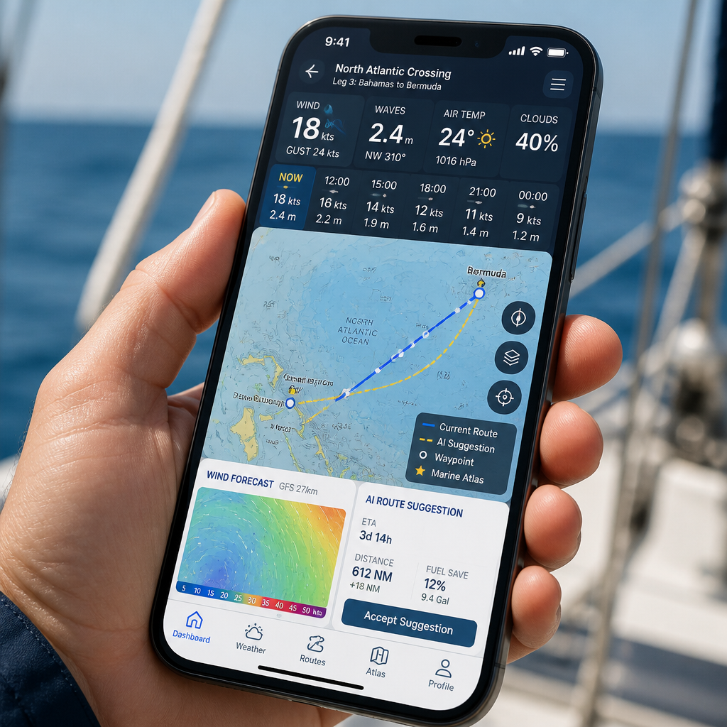
If you have spent any time hunting for a coastal sailing app that actually covers navigation, weather, education, and passage planning in one place, you have probably noticed that most tools do one thing well and leave you patching together a second or third app to cover the rest. That fragmentation is not a minor inconvenience. Mid-passage, switching between three apps while monitoring a VHF and trimming sails is a real operational risk. This coastal sailing app comparison examines what separates a genuinely integrated instrument from a collection of single-purpose utilities, using MARLOG as the benchmark and measuring every dimension that matters to coastal sailors and marine navigators.
Quick Takeaways
- Integration beats collection: MARLOG combines atlas, weather, education, and AI route planning in a single iOS instrument. Single-purpose tools require you to switch apps at the worst possible moments.
- Weather model source matters: MARLOG uses both Apple Weather and Copernicus marine models. Generic weather tools often rely on a single atmospheric model without ocean-specific layers like sea state and current data.
- Community reviews are not seamanship data: Anchorage discovery apps built on community reviews are useful for marina ratings, but they do not replace charted maritime places, tidal windows, or COLREGS decision support.
- Sailing windows are a distinct forecast category: Knowing wind speed is not the same as knowing whether a departure window is viable. MARLOG's passage planning calculates actual sailing windows, not just raw meteorological data.
- Education onboard reduces real incidents: Having 16 seamanship courses and 288 practice exercises accessible offline means crew can refresh collision avoidance rules before a busy shipping lane, not just at home.
- Atlas depth determines real-world usefulness: 1,160 charted maritime places worldwide is a specific, navigable dataset. Generic map layers on weather tools are not purpose-built for coastal passage planning.
- AI compass changes how route decisions are made: An AI-assisted compass that interprets COLREGS and route conditions in context is a different class of decision support from a static weather overlay or a marina rating.
Most sailors arrive at this comparison after experiencing the same frustration: they download a popular weather visualization tool for wind forecasts, then a community marina app for anchorage ratings, and then realize neither one helps them plan a passage, study for their next certificate, or understand a right-of-way situation at 2 a.m. in a busy strait. The question is not which single app is best at its single job. The question is which app functions as a real navigational instrument for the full sailing workflow.
What Coastal Sailors Actually Need from an App
Coastal sailing has a specific risk profile that is different from offshore bluewater passages or river boating. You are working with changing tidal windows, busy shipping traffic, frequent port entries, and short decision cycles. An app that serves this profile well has to cover at least four layers: spatial knowledge (what is around you and where), meteorological intelligence (not just wind speed, but passage viability), regulatory competence (COLREGS, lights, shapes, sound signals), and route logic (how to go from A to B given all the above).
Most apps on the market address one of these layers. A weather visualization tool addresses meteorology. A community anchorage app addresses spatial knowledge of marinas and anchorages. A COLREGS quiz app addresses regulatory competence. None of these individually address route logic, and none of them talk to each other.
The real cost of app-switching. A common mistake among sailors who have assembled a stack of single-purpose tools is underestimating how much mental overhead app-switching creates. Checking wind in one app, cross-referencing a marina in another, and then opening a third to review collision avoidance rules fragments your situational awareness at exactly the moments when you need it most concentrated. This is not a user experience complaint. It is a safety concern.
Pro tip: Before any coastal passage, test whether your entire pre-departure workflow, from route planning to weather windows to COLREGS review, can be completed without leaving a single app. If it cannot, your toolset is more fragmented than your sailing deserves.
The Single-Purpose Problem with Fragmented Tools
The two most commonly cited categories in this space are weather visualization apps and community marina discovery apps. Both serve real needs. Neither serves the full need of a coastal sailor who is also trying to build seamanship competence and plan safe, timed passages.
Weather visualization tools in this category typically offer layered wind maps, wave height overlays, and atmospheric model data that is visually compelling and genuinely useful for understanding synoptic conditions. Where they fall short is in translating raw meteorological data into actionable sailing windows. Showing that wind will be 18 knots from the southwest is not the same as computing whether a specific departure time, given tidal flow, sea state, and boat characteristics, is viable for a passage from one coastal point to another.
Where community marina apps stop short. Community-driven anchorage and marina tools have built large user bases by crowd-sourcing reviews, photos, and ratings. That information has genuine value when you are deciding between two anchorages of similar quality. It has almost no value when you need to know whether the entry channel depth allows your draft on a falling tide, or whether the headland between you and your destination will block a VHF signal. These are navigational questions, not hospitality questions.
The structural problem with community-rating apps is that their core value proposition, social proof from other sailors, is not the same as charted, verified maritime data. A four-star anchorage review does not tell you anything about COLREGS compliance in the approaches, tidal exposure, or the meteorological window for your specific departure date.
The most dangerous moment in coastal sailing is when a sailor mistakes convenience for competence. An app that makes it easy to find a well-reviewed anchorage does not make it easy to arrive there safely.
MARLOG Feature by Feature
MARLOG is built specifically for coastal sailors and marine navigators on iOS. Rather than specializing in one layer of the sailing workflow, it integrates four distinct capabilities into a single instrument. Understanding each one separately is necessary to understand why the integration matters.
Maritime atlas: 1,160 charted places worldwide. The atlas layer covers 1,160 charted maritime places worldwide. This is not a generic map layer or a crowd-sourced pin database. These are purpose-built navigational reference points for coastal passage planning. For a sailor planning a multi-leg coastal cruise, having a structured atlas that covers ports, anchorages, and waypoints in a navigable format means less time cross-referencing paper pilots and more time on actual passage planning.
Real-time marine forecasting with sailing windows. MARLOG draws on Apple Weather and Copernicus marine models to generate weather data. The Copernicus marine service provides ocean-specific data layers, including sea state, surface currents, and swell direction, that atmospheric models alone do not capture. The combination is more relevant to passage planning than a single-model atmospheric overlay. Critically, the app translates this data into sailing windows rather than leaving the interpretation entirely to the sailor.
Seamanship academy: 16 courses, 288 practice exercises. This is where MARLOG separates itself most clearly from weather and marina tools. A seamanship academy with 16 structured courses and 288 practice exercises embedded in the same app means that crew preparation, COLREGS review, and seamanship education happen in the same navigational environment where you are planning your passage. This is not an afterthought feature. For yacht owners building crew competence, or solo sailors preparing for a busier coastal route, it is a first-class capability.
AI compass for route planning and COLREGS. The AI compass provides decision support for route planning and collision avoidance under COLREGS. This is a materially different class of tool from a static wind overlay. COLREGS interpretation in real traffic situations involves reading vessel types, lights, and relative bearings simultaneously. An AI-assisted compass that contextualizes this information as part of route planning reduces the cognitive load at the moments when cognitive load is already highest.
Head-to-Head Comparison: Integration vs. Specialization
The table below compares MARLOG against the two dominant categories of competing tools in this space: weather visualization apps and community marina discovery apps. The comparison uses the four layers that matter for coastal sailing workflow.
- Maritime atlas of charted places: MARLOG: 1,160 charted maritime places worldwide; Weather Visualization Tools: Generic map layer, not passage-planning specific; Community Marina Apps: Community-rated anchorages and marinas (35,000+).
- Weather and forecasting: MARLOG: Apple Weather + Copernicus marine models with sailing windows; Weather Visualization Tools: Strong multi-model atmospheric data, wind maps, wave overlays; Community Marina Apps: Basic 72-hour anchorage weather check, not passage-specific.
- Passage and route planning: MARLOG: AI compass with route planning and COLREGS support; Weather Visualization Tools: Visual wind overlays only, no route planning logic; Community Marina Apps: Basic route planning, no COLREGS or tidal window logic.
- Seamanship education: MARLOG: 16 courses, 288 practice exercises, COLREGS training; Weather Visualization Tools: None; Community Marina Apps: None.
- Platform: MARLOG: iOS native; Weather Visualization Tools: iOS and Android, web browser; Community Marina Apps: iOS and Android.
- Community features: MARLOG: Navigational data-focused; Weather Visualization Tools: Limited community features; Community Marina Apps: Core value proposition (1M+ users, reviews, photos).
- AI decision support: MARLOG: AI compass for routing and COLREGS; Weather Visualization Tools: Not available; Community Marina Apps: Not available.
The pattern in this table is consistent. MARLOG is not the best tool in any single row if you define "best" as deepest specialization. It does not have more community reviews than a dedicated marina app, and it does not have as many atmospheric model overlays as a dedicated weather visualization tool. What it does have is coverage across all four rows, which is what a coastal sailor actually needs in a single instrument.
Pro tip: If you are evaluating sailing apps, build a checklist of your last five pre-departure decisions: weather check, route verification, anchorage selection, COLREGS refresh, and passage window calculation. Count how many apps you opened. If the answer is more than one, the gap that costs you is integration, not features.
Weather and Forecasting Depth
Weather is the area where the comparison requires the most precision, because it is the area where differences in data source matter most to safety outcomes. Generic atmospheric model forecasts, presented as animated wind overlays, are genuinely useful for understanding large-scale synoptic patterns. They are not purpose-built for marine passage planning.
The Copernicus Marine Service, which MARLOG integrates, is a European Union programme that provides marine environmental data specifically designed for ocean applications. This includes ocean current analysis, sea surface temperature, wave spectra, and sea level data. An atmospheric wind model and an ocean model are different instruments measuring different phenomena. For coastal passage planning, particularly in areas with strong tidal streams or coastal current effects, ocean-specific data is not optional.
Sailing windows versus raw forecast data. The most practically important distinction is the difference between showing forecast data and computing a sailing window. A raw wind speed forecast tells you what conditions will be. A sailing window tells you whether those conditions, combined with expected sea state, tidal flow, and your departure point, create a viable passage opportunity. These are different calculations. MARLOG's real-time forecasting is designed to produce the second output, not just the first.
In practice, the difference becomes critical on coastal passages where the window between a calm departure and an exposed headland rounding is narrow. A visually impressive wind map that shows 15 knots at 1400 does not tell you whether 1400 is the right departure time from your specific berth to clear that headland before the ebb tide and the afternoon sea breeze combine.
Seamanship Education and COLREGS
No other category of feature separates MARLOG from the rest of the field as clearly as embedded seamanship education. This is not an area where weather tools or marina discovery apps compete at all. The question is whether it matters to have education inside a navigation app or whether keeping a separate study app is acceptable.
The argument for keeping education separate is convenience: study apps built specifically for RYA, ASA, or equivalent exam preparation may have deeper question banks and better spaced repetition algorithms. That argument has merit for dedicated exam study at home.
The argument for integrated education is operational: a sailor who can review a COLREGS scenario, check the relevant rule, and immediately cross-reference it against their current passage plan is engaging with the material in context. Context accelerates retention and, more importantly, context accelerates application. Understanding Rule 16 in a quiz is different from understanding it while looking at your planned route through a busy ferry crossing.
COLREGS and AI decision support working together. MARLOG's AI compass for COLREGS collision avoidance is not a replacement for formal seamanship training. It is a decision support layer that operates alongside the 16 courses and 288 exercises in the academy. This pairing is deliberate and correct. The AI assists with contextual interpretation. The academy provides the foundational knowledge that makes that assistance meaningful rather than a black box. Sailors who use both together develop faster situational awareness than those who rely on either tool in isolation.
Which Sailor Should Choose Which Tool
Direct positions are more useful than hedged recommendations here. Here is the honest assessment of who should use what.
Use MARLOG if you are a coastal sailor who wants one iOS instrument that covers your full pre-departure and passage workflow. This is the correct choice for yacht owners who are actively building navigational competence, sailors who are preparing for certificate exams while also planning real passages, and anyone who has felt the operational friction of managing a stack of single-purpose sailing apps. The integrated AI compass, atlas, forecasting, and education make it the only tool in this comparison that is genuinely designed for the whole job.
Consider a dedicated weather visualization tool as a supplement, not a replacement, if you are managing a complex offshore passage where access to multiple atmospheric model overlays is valuable for synoptic analysis. In that role, a weather visualization tool is a professional instrument. For routine coastal sailing, MARLOG's Copernicus-backed marine forecasting covers the relevant data layers without requiring a separate app.
Consider a community marina app as a supplement for destination research in cruising grounds where the crowd-sourced review density is high. If you are planning a cruise through a well-documented sailing area and want peer reviews of anchorage holding quality or marina facilities, community data has real value. It does not have value as a navigation instrument. Use it the way you would use a cruising guide: as contextual intelligence, not as a primary navigational tool.
The short version: MARLOG is the primary instrument. Everything else is optional supplementary reference.
Frequently Asked Questions
Is MARLOG suitable for sailors who are still learning, or is it designed for experienced navigators? MARLOG is explicitly designed to serve both groups at once. The seamanship academy with 16 courses and 288 practice exercises is built for sailors who are actively developing their skills. The atlas, AI compass, and forecasting tools are built for navigators making real passage decisions. A less experienced sailor who uses the education features while planning actual passages learns faster than one who keeps study and navigation in separate apps, because the context reinforces the theory immediately.
Does MARLOG work offline, and is that important for coastal sailing? Offline capability is critical for coastal sailing. Cellular coverage becomes unreliable in many coastal and nearshore areas, particularly in approaches to remote anchorages or when sailing below cliffs and headlands. Any app that requires a live data connection for its core navigation or education functions is operationally unreliable on the water. Check MARLOG's specific offline capabilities for charts and academy content before departure on any passage beyond reliable coverage areas.
How does Copernicus marine data differ from standard weather forecast models? Standard atmospheric weather models simulate the atmosphere and produce wind, precipitation, and pressure data. Copernicus marine models simulate the ocean and produce sea state, surface current, wave spectra, and sea surface temperature data. For coastal passage planning, both layers are relevant. A wind forecast alone does not tell you about a counter-current that will slow your passage or a swell wrapping around a headland that will make an anchorage uncomfortable. MARLOG's integration of both data types produces more complete passage intelligence than atmospheric-only weather tools.
Can I use MARLOG as a navily alternative for marina discovery and anchorage planning? MARLOG's atlas of 1,160 charted maritime places addresses the navigational dimension of anchorage and port selection. It is not a community review platform, so it does not replicate the crowd-sourced facility ratings and photos that dedicated marina apps offer. If your primary need is reading other sailors' reviews of marina showers and holding quality, a community app serves that specific need. If your primary need is planning a coastal passage to a destination and understanding the nautical context of that destination, MARLOG's charted atlas and forecasting are the more relevant tools.
What makes an AI compass for COLREGS more useful than just studying the rules? COLREGS governs collision avoidance in real traffic situations involving relative motion, vessel type identification, and time-sensitive decisions. Knowing the rules in abstract is necessary but not sufficient. An AI compass that applies COLREGS logic to your current route and traffic environment contextualizes the rules at the moment they are relevant, which is a different cognitive task from studying them at anchor the night before. The two tools, the AI compass and the seamanship academy, are complements, not substitutes. The academy builds the understanding. The compass applies it in context.
Is MARLOG only for iOS, and does that limit who can use it? MARLOG is designed specifically for iOS, which means it is not available on Android. For the target audience of yacht owners and coastal sailors who use Apple devices, this is not a practical limitation. The iOS-native build also means MARLOG can integrate with Apple Weather's data pipeline in ways that cross-platform apps cannot. If your primary sailing device is an Android phone or tablet, MARLOG is not currently an option, and you would need to evaluate other tools for your full workflow.
If you have used MARLOG, a weather visualization tool, or a community marina app as part of your coastal sailing workflow, share what you found indispensable and what you ended up ignoring, because the real-world gap between feature lists and actual underway usefulness is where the most useful comparisons live.