What Is a Sailing Window and How to Read One
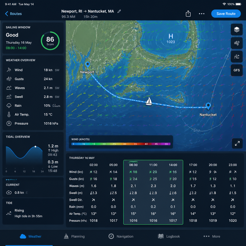
Most passage planning mistakes happen before the anchor comes up. Sailors spend hours studying charts, checking tides, and reviewing waypoints, then depart into a forecast they never properly understood. A sailing window is the specific period of favorable conditions that makes a passage safe, manageable, and worth attempting. Read it correctly and you arrive on schedule. Ignore it and you spend 36 hours punching into a Force 7 you could have waited out in harbor. This guide explains exactly what a sailing window is, what elements define it, and how to read one before every passage.
What Is a Sailing Window
A sailing window is a period of favorable weather conditions that allows for a safe and efficient passage, covering either the full duration of the trip or at least its critical opening phase. It is not simply "no rain" or "light winds." A true sailing window accounts for wind speed, wind direction, wave height, swell period, tidal gates, and the forecast trend over the next 24 to 72 hours.
The distinction between a sailing window and a "decent day" matters enormously offshore. Conditions that feel comfortable at the marina entrance can deteriorate rapidly 20 miles out, especially when wind-against-tide creates short, steep seas. The window must account for how long your passage takes, not just how conditions look at departure.
Every passage has a minimum viable window. A coastal hop of four hours has different requirements than a 48-hour offshore run. Defining the window begins with knowing your boat's passage time, your crew's capability, and your destination's access constraints, such as a harbor entrance that is dangerous in any swell above 1.5 meters.
Quick Takeaways
- A sailing window covers the entire passage, not just departure: Check the forecast for the full duration of your estimated passage time, not only for the first few hours after leaving the dock.
- Wave period is as important as wave height: Short-period waves of 5 to 6 seconds are far more dangerous and uncomfortable than longer swell of the same height at 10 to 12 seconds. Never assess height in isolation.
- Wind direction beats wind speed: A Force 5 on the beam is a fast, comfortable passage. The same Force 5 on the nose in a tidal channel is a miserable, slow slog that exhausts crew and damages gear.
- Tidal gates define the usable slot inside the window: Many harbors, headlands, and straits have a tidal gate. Missing it can extend a passage by hours or make it dangerous, regardless of the weather.
- Forecast confidence degrades after 48 hours: Use the first 48 hours of a marine forecast with confidence for departure decisions. Treat the 72-hour outlook as directional guidance only, not a firm commitment.
- Multiple weather models reduce single-model risk: When GFS, ECMWF, and regional models disagree significantly, that disagreement is itself a warning. Do not depart when models diverge sharply on wind speed or storm timing.
- Crew capability narrows the window further: An experienced offshore crew can sail in conditions that would overwhelm a mixed crew on the same boat. Define your window against your weakest crew member, not your best.
The sailing window concept connects every element of passage planning into a single decision. Wind, waves, tides, forecast reliability, and human factors all converge at the moment you decide whether to depart or wait.
The Five Parameters That Define a Sailing Window
Experienced sailors do not check a single forecast variable. They assess five parameters in combination. Each one can independently close a window that looks good on every other measure.
1. Wind Speed and Direction. Set your personal wind speed limits before you read the forecast, not after. A common working limit for a coastal cruising yacht with a mixed crew is Force 5 (17 to 21 knots). Above Force 6 (22 to 27 knots), conditions on an exposed coast escalate quickly. Wind direction determines whether those knots are useful or punishing. Beam or broad-reaching winds move the boat efficiently. Headwinds in a tidal channel create the worst sea states at any given wind speed.
Check not just the forecast wind at departure but the predicted wind at your estimated time of arrival. Conditions that are Force 4 at 0600 can be Force 6 by 1400 due to thermal development along a coastline. The sailing window must remain open for the entire passage, not just the start.
2. Wave Height and Swell Period. Marine forecasts report two distinct wave components: wind waves generated by local conditions, and swell generated by distant weather systems. Both are present on most coastal passages. You must check both.
Wave height in feet compared to wave period in seconds is a practical ratio worth memorizing. When wave height in feet approaches the period in seconds, the sea is steep and uncomfortable. A 3-foot wave at 5 seconds of period is a nasty chop. A 6-foot wave at 14 seconds of period is a long ocean swell that most boats ride smoothly. Swell from multiple directions at the same time creates cross-seas, which are the most dangerous condition for a coastal passage and require their own assessment.
3. Tidal Currents and Gates. Tides and tidal currents are predictable, which gives sailors a genuine planning advantage. Calculate your tidal gates first, then fit the weather window around them. Attempting a headland, inlet, or narrow channel against a 3-knot tidal current wastes fuel, increases apparent wind, and shortens your window by extending passage time. In some areas, wind-against-tide combinations create dangerous, steep sea states even in moderate winds.
4. Forecast Trend and Pressure Pattern. A single snapshot of a marine forecast tells you less than the trend across the next 48 hours. A falling barometer narrowing the isobars is a closing window, even if current conditions look fine. Conversely, a rising barometer after a front passage often signals the best sailing window of the week: clearing skies, wind backing to the northwest in the northern hemisphere, and a flattening sea state. Read the synoptic chart, not just the hourly grid.
5. Visibility and Daylight. Fog, rain squalls, and reduced visibility are passage-stoppers for coastal sailors in busy shipping lanes or approaching unfamiliar harbors. Plan your arrival during daylight, particularly in harbors with unlighted leading marks or shallow approach channels. Arriving after dark at an unfamiliar port eliminates half the information you rely on for safe entry. Build daylight arrival into your window calculation as a hard constraint, not a preference.
How to Read a Marine Forecast for Passage Planning
Reading a marine forecast for passage planning is a structured process. Work through it in the same order every time, and you will not miss anything critical.
Start with the synoptic overview. Identify the pressure systems affecting your area, their movement, and their speed. A fast-moving frontal system may close your window within hours; a slow-moving high may open a five-day window. Know which type you are dealing with before you look at hourly wind forecasts.
The most important thing a forecast tells you is not what conditions are now, but how quickly they will change and in which direction. A good sailing window is not just a moment of favorable conditions, it is a stable trend.
Next, check multiple forecast models. When global models such as GFS and ECMWF agree, confidence in the forecast is high. When they diverge significantly on storm timing or wind speed, that divergence is a direct signal: the forecast carries high uncertainty, and departing into uncertain conditions is a risk management decision, not just a weather decision. Tools that integrate multiple models side by side give you this perspective in seconds.
Pro tip: Always load the marine forecast for your destination port, not only your departure point. Conditions can be dramatically different 40 miles along the coast, especially when sea breezes, coastal geography, or tidal races affect the endpoint of your passage.
Overlay your tidal plan onto the forecast grid. Map out the hours when tidal gates are favorable and mark them against the forecast window. Your actual departure slot is the overlap between acceptable weather and favorable tides. In many coastal passages, this overlap is only two to four hours. Missing it means waiting for the next cycle.
Finally, check the swell forecast independently from the wind forecast. Wind forecasts update frequently; swell from a distant storm can arrive on your coast with 12 to 24 hours of lag. A swell model that integrates ocean current data, such as the Copernicus marine models, gives you the most accurate picture of what the sea surface will actually look like when you arrive at a headland or harbor entrance.
Common Mistakes When Evaluating a Sailing Window
The errors that put sailors in difficulty are predictable and preventable. They are not failures of seamanship once at sea. They are failures of judgment made in the harbor, often under social or logistical pressure to depart.
Mistaking a Short Good Window for a Full Passage Window. A four-hour window of light winds does not cover a ten-hour passage. Calculate your passage time honestly, add a margin for adverse current, light winds, or crew fatigue, and then confirm that the window extends to cover the realistic worst-case arrival time. Experienced passage planners add 20 to 25 percent to their estimated passage time before checking whether the window holds.
Using a Single Weather Model. Relying on one forecast source is a structural error. Every numerical weather prediction model has biases, grid resolution limits, and failure modes. A marine forecast that integrates multiple models, including global atmospheric models and regional ocean models, gives you the redundancy to catch a model outlier before it catches you at sea.
Ignoring Crew Capability as a Planning Variable. A sailing window is not defined by your boat's capability alone. Define acceptable conditions against the realistic capability of the crew on board for this specific passage. A guest crew member on their second offshore passage changes the acceptable wind and sea state limits materially. Adjust your window criteria accordingly before you read a single weather chart.
Pro tip: Use the MARLOG app to cross-reference your passage route against real-time marine forecasting and Copernicus ocean model data before committing to a departure time. The integrated sailing window tool shows you the forecast across your full passage time, not just at the departure point, so you see the complete picture in one instrument.
Anchoring to the Original Plan. The plan you made three days before departure is not sacred. Forecast updates 24 hours before departure are significantly more accurate than the forecast you read at the planning stage. Check again the evening before, and check again on the morning of departure. If the updated forecast closes the window, the window is closed. Sunk cost thinking ("we've already provisioned") has no place in passage planning.
Comparing Sailing Window Assessment Approaches
Sailors use different approaches to assess a sailing window depending on passage type and available tools. Each approach has a defined use case and a defined weakness.
- Single-source marine forecast (text or grid): Best Use Case: Day sails and short coastal hops under 6 hours in familiar waters; Key Limitation: No model comparison, no swell data, no tidal integration. Misses model divergence signals entirely..
- Multi-model GRIB data review: Best Use Case: Overnight and offshore passages of 24 hours or more; Key Limitation: Requires weather interpretation skills. Raw GRIB data without routing context does not show how conditions interact with your specific route or tidal plan..
- Integrated passage planning app with marine models: Best Use Case: All coastal and offshore passages where timing precision matters; Key Limitation: Only as good as the underlying models and the frequency of updates. The best tools combine global atmospheric models with regional ocean and swell models and refresh at least every 6 hours..
The practical standard for serious coastal passage planning is the integrated approach. Combining atmospheric forecast data with Copernicus ocean model outputs for sea state, current, and swell gives a picture that a single-source text forecast cannot match. MARLOG builds this integration directly into the passage planning workflow, cross-referencing Apple Weather data and Copernicus marine models against your specific route waypoints so that the sailing window is evaluated along the entire track, not just at the departure marina.
Frequently Asked Questions
How long does a sailing window typically last? It varies with the synoptic situation. A high-pressure system can hold a stable sailing window for three to five days. A frontal passage might offer a post-frontal window of only 12 to 24 hours before the next depression closes it. For coastal passages, a 48-hour stable window is comfortable. For passages over 400 nautical miles, you need at least a 4-day window with a stable pressure trend backing it up.
What is the difference between a weather window and a sailing window? The terms are used interchangeably in practice, but a sailing window is the more precise term. A weather window refers to any period of favorable atmospheric conditions. A sailing window specifically accounts for the full passage requirements: wind, waves, tides, passage duration, crew capability, and destination access. A weather window is a necessary but not sufficient condition for a sailing window.
What wind speed is too strong to sail in for a coastal passage? The answer is boat-specific and crew-specific, but a widely used practical limit for a crewed coastal cruiser is Force 6 (22 to 27 knots). Above this, a Small Craft Advisory threshold of sustained winds over 21 to 33 knots signals that most recreational vessels should reassess. The decision also depends on direction: Force 6 downwind is manageable; Force 6 on the nose in a tidal race is dangerous. Set your own limits before you read the forecast, not after.
How far ahead should I plan my sailing window? Start the planning process 5 to 7 days out to understand the synoptic pattern. Make a provisional departure decision at 48 to 72 hours, when forecast accuracy improves substantially. Do a final check the evening before departure and again the morning of. Forecast skill degrades significantly beyond 5 days, so any commitment made more than a week in advance must be treated as provisional.
Can I use a mobile app to find a sailing window accurately? Yes, provided the app integrates multiple weather models and marine data sources rather than pulling from a single provider. The best mobile tools for passage planning use both global atmospheric models and ocean-specific models, such as Copernicus marine service data, to deliver swell, current, and sea-state forecasts alongside wind and pressure. Apps that show the forecast along your actual route rather than only at a fixed point give substantially more useful sailing window assessments.
What does "passage planning weather" involve beyond checking the wind forecast? Passage planning weather assessment covers the full synoptic picture: pressure system identification and movement, wind speed and direction at departure and arrival, wave height, swell period, swell direction, tidal current predictions, visibility forecasts, and the confidence level indicated by model agreement. For any passage longer than a day sail, it also includes contingency routing: identifying waypoints where you can divert to shelter if conditions deteriorate faster than forecast.
How does MARLOG help with sailing window planning? MARLOG integrates real-time marine forecasting directly into its passage planning workflow, combining Apple Weather data with Copernicus marine model outputs for sea state, ocean currents, and swell. The app evaluates the sailing window across your full route rather than at a single point, allowing you to see where forecast conditions fall outside your defined limits anywhere along the track. The AI compass feature assists with route planning and COLREGS collision avoidance as a complementary seamanship tool.
Share your experience below: what is the most useful single variable you check when deciding whether a sailing window is genuinely open or not?
References
- How to find the right weather window for a sailing passage, Yachting World
- Practical guide to picking weather windows for coastal passages, The Boat Galley
- How to read a marine weather forecast including Beaufort scale and advisory thresholds, AMN Nautical
- Seven-day wind and wave sailing forecasts for passage planning, PassageWeather